Location and structure
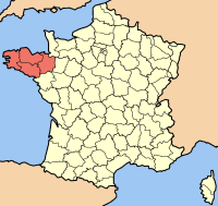
Brittany lies in north-western France between the Atlantic and the English Channel and, with an area of a little over 27,000 square kilometres, is France’s largest peninsula. During the French Revolution, historical Brittany was divided into departments. Bretons traditionally distinguish between Armor, the land by the sea, and Argoat, the land of the forest.
History
Little is known about the earliest inhabitants of Brittany. After Julius Caesar’s conquest of Gaul in 56 BCE, Romanization also began in the region.

From the middle of the fifth century, Celtic Britons migrated from Britain to the region. These immigrants gave Brittany its name and played a major role in its Christianization.
Language
Breton, Brezhoneg, is not a French dialect but an independent Celtic language. Together with Welsh and Cornish it belongs to the Brittonic branch of the Celtic languages. Breton is the only modern Celtic language spoken on the European mainland.
The history of Breton is also a history of language policy. From the late nineteenth century onward, the expansion of compulsory schooling in France was accompanied by strong pressure against regional languages. Breton was forbidden in schools for long periods; later policy changed and regional languages gained limited recognition.
Economy and coastal life
Agriculture, food production, fishing and tourism have all played major roles in the regional economy. Coastal areas in particular are strongly shaped by maritime life and seasonal tourism.